
Review · KYRGYZSTAN
8 Days Trekking in Kyrgyzstan: Alay Mountains Adventure
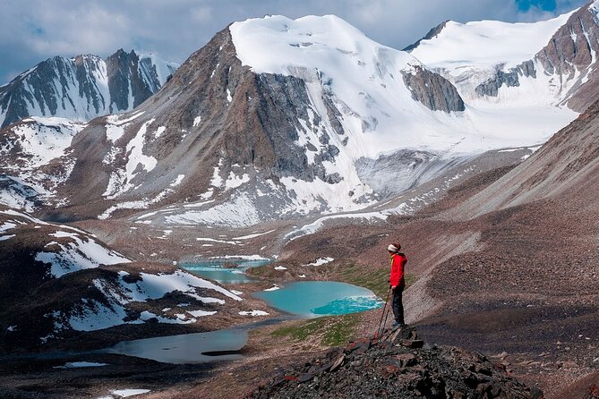
The striking thing about this eight-day Alay Mountains trek is how quickly the scenery changes. One day you are walking through a broad green valley, the next you are crossing a high pass with glaciers, red rock, and dry mountain terrain in view. It is a real point-to-point journey, not a series of short walks from one hotel.
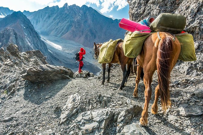
I like the mix of serious mountain walking and local hospitality. You sleep in yurts and homestays, eat Kyrgyz food, and meet shepherds whose lives still follow the seasons. I also like that your main luggage can go by horse, leaving you with a daypack instead of a heavy load.
The catch is the workload. Several days run 15 to 24 kilometers, with up to 1,299 meters of climbing. This is not a gentle sightseeing tour, and the shared sleeping arrangements, basic washing facilities, weather, and altitude will test your comfort as much as your legs.
Key points to know before booking
- Walk from Sary-Mogul through changing mountain country: Expect alpine lakes, glacier views, red rock, dry high valleys, and wide green grasslands.
- Sleep in yurts and homestays: Rooms are shared by three to five people, giving the trip a strong local and social feel.
- Prepare for long trekking days: Day five covers 24 kilometers, while days three, four, and six include major climbs and descents.
- Horse support carries up to 15 kilograms: You still need a daypack with water, layers, and personal essentials.
- Reach Lake Tulpar-Kol and Peak Lenin Base Camp: The final section adds a high-mountain finish and a border permit.
- The price includes most major trip costs: At $1,100 per person, transport, meals, guide service, permits, horses, and lodging are included.
Why the Alay Mountains feel different
Kyrgyzstan is famous for its open mountain country, but the Alay region gives you more than one type of view. The route moves between soft valley grass, bare slopes, red rock formations, snow and ice, and lake country. That variety keeps the trek interesting because the scenery does not settle into one repeated pattern.
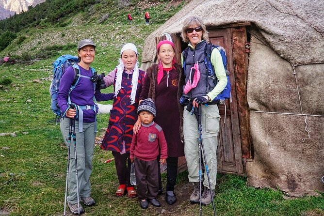
The route also shows you a working mountain culture. Yurts are not just decorative camp cabins here. They are part of the seasonal life of Kyrgyz families and shepherds. A meal in a yurt, a conversation with local hosts, or a glimpse of animals moving through the high pastures gives the walk a human center.
This is community-based tourism in a practical sense. Local people provide accommodation, meals, transport, horses, and guiding support. Your money is spread among those services instead of going only to a large hotel or an international operator.
The experience has a 4.9 out of 5 rating from 90 ratings, with 97 percent recommending it. The strongest praise centers on the scenery, organization, guides, and care shown to slower walkers. That said, one sharply negative account raises concerns about hygiene, group-size expectations, payment rules, and support when people became ill. I would treat that as a reminder to ask clear questions before departure rather than ignore it.
More treks around the world:
- Mount Etna: Trek to 3000m with cable car and 4×4
★ 4.6 · 3,823 reviews - Bali: Mount Batur Sunrise Trek With Guide and Breakfast
★ 4.8 · 3,461 reviews - From Chania: Full-Day Samaria Gorge Trek Excursion & Guide
★ 4.6 · 3,191 reviews
Day one: Osh to Sary-Mogul and the first mountain walk
The trip begins in Osh, at the stated meeting point on Kurmanjan Datka Street. From there, you drive about 220 kilometers to Sary-Mogul, a high village at roughly 3,000 meters. The drive takes about four hours, though the full day is listed at around five hours once the walking is included.
This transfer is important because it takes you out of the city and directly into the mountain setting. The scenery begins changing along the road, and you get your first sense of the scale of the Alay region.
The opening walk covers about six kilometers and takes three to four hours. It is a sensible introduction to the route, but the altitude makes even an easy walk feel more demanding than the distance suggests. Take the first day slowly, drink regularly, and do not use the opening miles to prove your fitness.
Sary-Mogul is also where the trip’s rhythm begins. You are no longer moving from one conventional hotel to another. The focus shifts to walking, simple lodging, shared meals, and the practical realities of mountain travel.
Day two: Open valleys and the first yurt camp
Day two covers about 14 kilometers in four to five hours, with a modest ascent of 461 meters and a descent of 115 meters. The route follows an easy car road through broad open valleys toward the first yurt camp.
This is one of the gentler walking days, useful for settling into the group and getting used to the pace. The road surface may feel less exciting than a narrow mountain trail, but it gives you time to look around, talk with your guide, and absorb the wide Kyrgyz setting.
The yurt camp is a major part of the appeal. You sleep in shared rooms, normally with three to five people. Facilities are likely to be simpler than you would find in town, and the provided information does not promise private bathrooms or hotel-style comforts. If you can accept that, the yurt is a valuable part of the trip rather than a compromise.
Meals are included, with breakfast and dinner provided throughout the trek and lunches included each day. A vegetarian option is available, according to the trip information and recent feedback, but you should still state your dietary needs clearly when booking.
Day three: A longer climb into higher country
After breakfast, you drive about 30 minutes north from Sary-Mogul to the trailhead. The walk covers roughly 15 kilometers and takes eight to nine hours. With 1,059 meters of climbing and 859 meters of descent, this is where the trek becomes distinctly harder.
The route leads into more remote mountain country, with broad views and changing rock forms. The details of the exact trail are less important than the effort involved: you need steady pacing, good footwear, and enough food and water for a full day outside.
This is also a day when guide support matters. Guides associated with recent departures include Ernis, Dastan, Azi, Asan, and Eshim. The most useful guides on a route like this are not simply the fastest walkers. They keep the group together, explain local customs, and notice when someone needs a slower pace or a short vehicle transfer.
Do not assume every departure will have the same named guide. Ask who is assigned to your group and how the pace is managed before you pay the balance.
Same mountains, a different route up:
- Mount Etna: Summit Crater Trek with Cable Car
★ 4.8 · 1,875 reviews - La Palma: Tajogaite Volcano Guided Trek
★ 4.8 · 1,810 reviews - Etna: summit craters trekking with volcano guide 3350mt
★ 4.7 · 1,712 reviews - From Rethymno: Samaria Gorge Full-Day Trek, Pickup & Guide
★ 4.5 · 1,610 reviews
Day four: From rocky alpine ground to greener valleys
Day four covers about 19.4 kilometers, with seven to eight hours on the trail. You descend 1,596 meters after an 866-meter ascent, so the day is not easy simply because much of it goes downhill.
The route begins with a relatively gentle descent, then follows a valley across rivers and between rocky alpine terrain and greener ground with juniper. River crossings add interest, but they also make weather and trail conditions relevant. Good walking shoes are essential, and trekking poles could be useful for the long descent, though poles are not listed as part of the equipment.
The change in scenery is the reward. The trail shifts from hard, exposed mountain surfaces to softer valley country. This is the sort of day that shows why the route is worth the physical work: you are not just climbing to a viewpoint and returning by the same path.
A long descent can be tougher on knees than a climb is on lungs. I would protect this day by keeping your pace controlled and not racing downhill to reach camp early.
Day five: Sarybell Pass and the longest walking day
Day five is the biggest test on paper. You walk about 24 kilometers over roughly nine hours, climbing 1,299 meters and descending 1,095 meters.
The day begins by crossing a stream and climbing to Sarybell Pass at 3,132 meters. The ascent takes about an hour according to the schedule, followed by views toward the Kichik Alay Mountains. From there, the trail continues through high country and eventually toward the next camp.
This is a demanding combination of distance, climbing, and altitude. You need to manage your energy from the first hour. Eat during the walk, keep your layers easy to reach, and tell the guide early if you are feeling unwell. Waiting until the final descent can make a manageable problem much worse.
Altitude sickness is a real consideration throughout the trip. The itinerary begins at about 3,000 meters, then takes you higher. One person specifically found Diamox helpful, but medication decisions belong with your doctor. The safer practical approach is to arrive rested, ascend at a sensible pace, stay hydrated, and report symptoms promptly.
Day six: Jiptok Pass and a serious mountain crossing
Day six covers about 16 kilometers in eight hours, with 1,150 meters of ascent and 931 meters of descent. From the yurt camp, you follow the river gradually toward Jiptok Pass, then climb a series of switchbacks.
The pass is the day’s main challenge. Switchbacks make the slope manageable, but they do not remove the effort. Once you reach the high point, the views reward the steady work, and the descent takes you toward another yurt camp.
This is a good example of the trip’s character. You are not being driven to scenic viewpoints with a short walk at the end. You earn the views through several hours of movement, and the reward comes from seeing the terrain open up as you gain height.
The yurt camp at the end of the day keeps the evening simple. Meals are provided, but you should expect a communal setup rather than a private dining room. The social side can be one of the best parts of the trip, especially if you enjoy comparing notes with people in the group after a hard day.
Day seven: A shorter walk, a homestay, and Lake Tulpar-Kol
Day seven is easier by trekking standards. You walk about 11 kilometers in roughly three hours, descending 320 meters with only 40 meters of climbing. The route leads to Sary-Mogul village, where you arrive at a homestay for a home-cooked lunch.
The break is useful. After several long days, a hot meal, shower, and WiFi give you a chance to recover. The schedule then continues toward Lake Tulpar-Kol, with transport taking you to the yurt camp area.
This day adds a different form of local contact. The homestay gives you more direct access to village life than a remote camp does, while the meal provides a welcome change after repeated days on the trail.
The itinerary lists both a homestay and a yurt camp during this section, so ask your operator to confirm the exact sleeping arrangement for your departure. Shared rooms remain the standard, with three to five people.
Day eight: Tulpar-Kol and Peak Lenin Base Camp
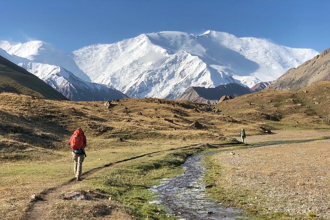
The final day begins early. From Lake Tulpar-Kol, you head south toward the alpine Peak Lenin Base Camp. The walking portion covers about 20 kilometers in six hours, with 760 meters of ascent and the same amount of descent. The full day also includes about five hours of driving.
Lake Tulpar-Kol gives the finish a strong visual focus. The route then reaches the base camp area, where the surrounding peaks and glaciers provide a fitting end to the trek. The border permit for Peak Lenin Base Camp is included, although last-minute permit requests can bring an extra charge.
This is not a relaxed final sightseeing stop. You still have a substantial walk and a long vehicle transfer. The early start helps, but you should keep some energy in reserve rather than treating the previous evening as a celebration night.
After the base camp visit, transport returns you to Osh and the original meeting point. The trip is therefore practical for people who want an organized route without arranging separate transfers between remote valleys.
What the $1,100 price really covers
At $1,100 per person, the cost is reasonable for an eight-day mountain trip with this level of support. You get an English-speaking guide, transport from Osh and back, transport to and from Tulpar-Kol, seven breakfasts, seven dinners, eight lunches, shared yurt and homestay accommodation, horse support, luggage service up to 15 kilograms, and the Peak Lenin border permit.
The horseman and luggage service add real value. Carrying everything yourself over several long days would make the route harder and less enjoyable. You still need a daypack, but the heavier bag can travel by horse.
The price does not include hotel stays or meals in Osh, tips, insurance, or services outside the standard program. Travel and health insurance are especially important for a high-altitude trek. Budget for at least one Osh hotel night and city meals before or after the route.
The group limit is 10 people. That is small enough for guide attention without making the trip a private departure. Still, group pace can affect your days, so ask how the operator handles different walking speeds.
Food, lodging, and the practical comfort level
Meals are part of the experience. Traditional Kyrgyz food is served through the route, and home-cooked meals in the village and yurt settings are one of the strongest cultural features. Vegetarian food is available, but communicate dietary requirements early.
Yurts and homestays are shared. That means you should pack with communal living in mind: a small towel, personal hygiene items, earplugs, and a way to keep clothing organized can make a difference. The information does not promise a particular toilet or shower standard at each camp, so do not book this expecting hotel conveniences.
A shower and WiFi are specifically available at the Sary-Mogul homestay on day seven. That break comes at a useful point, after the most demanding part of the route.
Who should book this trek?
I would choose this trip if you want a sustained mountain journey, care about local contact, and are comfortable with basic accommodation. It suits hikers who can manage 15 to 24 kilometers in a day and handle climbs above 3,000 meters.
You should think twice if you prefer short walks, private rooms, predictable weather, or easy access to medical facilities. The route is remote, physically demanding, and dependent on conditions. A moderate fitness level is the stated minimum, but I would prepare beyond that minimum with long uphill walks and back-to-back hiking days.
The trek also suits people who want their spending to support local families. Yurts, homestays, horsemen, drivers, and guides all form part of the trip’s local economy.
Booking details and weather concerns
The activity runs from June 16 through September 29, 2026, and operates Monday through Sunday within the stated hours. Pickup is offered, and confirmation is provided when you book.
You can cancel up to 24 hours before the start for a full refund. Changes or cancellations inside that period are not accepted or refunded. Poor weather can also cancel the departure, in which case you are offered another date or a full refund.
Ask about the exact group size, assigned guide, sleeping arrangements, dietary needs, luggage procedure, and permit timing before departure. The operator says the route can be customized according to your interests, which may help if you need adjustments to the standard program.
Should you book the Alay Mountains trek?
Book it if you want big scenery earned on foot, a strong taste of nomadic Kyrgyz life, and the convenience of having transport, food, horses, and permits arranged. The combination of yurt stays, homestays, long mountain days, and Peak Lenin Base Camp makes this more memorable than a simple guided walk.
Do not book it casually. The long distances, altitude, shared rooms, weather risk, and basic facilities are central parts of the experience, not minor details. If you arrive prepared and accept the rough edges, the $1,100 price gives you a lot: eight days of varied scenery, local support, and a route that would be difficult to arrange independently.
FAQ
Where does the trek begin and end?
It begins in Osh, Kyrgyzstan, at 128 Kurmanjan Datka. The activity ends back at the same meeting point in Osh.
How long is the tour?
The tour lasts approximately eight days.
What is the maximum group size?
The group can include a maximum of 10 people.
Is an English-speaking guide included?
Yes. An English-speaking trekking guide is included.
What type of accommodation is provided?
Accommodation is shared in yurts and homestays. Rooms normally hold three to five people.
Are meals included?
Yes. The package includes seven breakfasts, seven dinners, and eight lunches.
How much luggage can be carried by horse?
Luggage service covers up to 15 kilograms per person. A horseman is included.
Is the Peak Lenin Base Camp permit included?
Yes. The border permit for Peak Lenin Base Camp is included, but last-minute permit requests may require a surcharge.
What fitness level is needed?
A moderate level of physical fitness is required. The route includes days of up to 24 kilometers, climbs above 1,000 meters, and walking at high altitude.
New treks around the world
- Sapa: 2-Day Local Guided Valley Trek with Night Homestay★ 5.0 · 27 reviews
- SAPA: 1-DAY TREKKING TOUR WITH LOCALS, LUNCH & RICE FIELDS★ 4.7 · 18 reviews
- Sapa: 2-Day Local Guided Valley Trek with Night Homestay★ 4.8 · 5 reviews
- Santa Marta: Trekking in Minca Complete Waterfall Circuit★ 4.4 · 28 reviews
- Santiago: Longueira, Pico de Antónia & Monte Tchota Trek★ 4.8 · 10 reviews
- Santiago: Trek from Serra Malagueta to Rabelados Community★ 5.0 · 16 reviews
- Santiago Island: Serra Malagueta & Tarrafal Beach Trek Tour★ 4.8 · 61 reviews
- Santa Marta: Multi-Day Trek to The Lost City★ 4.8 · 40 reviews